
Upper Dennis Cove Falls
If you’re looking for a beautiful and adventurous hike, then check out out upper and lower Dennis Cove Falls in the Dennis Cove Recreational area. This hike is not overly strenuous and the trail is well-marked, but it does require three creek crossings that can range from moderate to extremely dangerous… depending upon the water level in the Laurel Fork stream. Staying dry can be a challenge.
Unlike most waterfall hikes, I recommend going on this one in the summer months when the stream will most likely have low flow. This should make the stream crossings manageable, fun, and even possible without getting wet. However, if you go when water levels are higher it could make this hike not only difficult to stay dry, but even dangerous if you must ford Laurel Fork in high-water conditions.
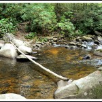
First Stream Crossing
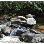
Third Stream Crossing
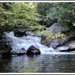
Lower Dennis Cove Falls
The trail begins near the Dennis Cove Campground, right next the bridge crossing the road. My general recommendation is to look at the water level below this bridge, and if the water is over shin deep, then save this hike for another time. Read my trail directions below for a better idea of what to expect on each of the three stream crossings, and for complete directions to both of these beautiful waterfalls.
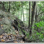
Rock Outcropping Immediately Before Taking the Spur Trail to the Upper Falls

Another Shot of Upper Dennis Cove Falls
_______________________________________________________________________________
|
–

———————————-
Overall
Recommendation:
Adventurous hike with fun stream crossings. Do it in low water conditions (summer months).
–
Outstanding
Features:
Two waterfalls.
–
Difficulty:
Easy (this is a rating of of how strenuous the hike is by elevation gain).
–
Driving:
Take Route 19E to the town of Hampton, TN. When in Hampton, go North onto Highway 321 toward Mountain City and Watauga Lake. In 0.8 miles take a right on Dennis Cove Road. Follow this road for 4.0 miles and you will come to the popular trailhead for Laurel Falls, which is also the Appalachian Trail. Continue past the Laurel Falls Trailhead for another 0.9 miles, and you’ll see a parking area on your left just before crossing the bridge. Park here.
–
Trails:
From the parking area, walk to the bridge, and you’ll see the trailhead next to the bridge marked with Cherokee National Forest sign (CNF Trail #39). Follow this yellow-blazed trail. You will need to make three stream crossings. The first crossing (see photo above) has a cable and usually a log crossing the stream. Taller folks can balance on this log while holding onto the cable and easily make this crossing. Crossing #2 (sorry no photo) also has a cable but did not have a log spanning the stream on my visit. However, I was able to stay dry by simple rock-hopping at this crossing. Crossing #3 is probably the most difficult (see photo above). It is located in quickly flowing, narrow section of the stream, with a small waterfall. There are some large boulders here that you can work your way across, but they are slippery and caution must be taken as you work your way from boulder to boulder. Once making the 3rd stream crossing, there is soon a spur trail that you will see leading down to the right. This goes to Lower Dennis Cove Falls. Return and continue on up the trail, where you will come to a rock outcropping (see photo). Almost immediately after this outcropping you will see another spur trail leading down to the right. This is the trail to Upper Dennis Cove Falls. This is at the 1.6 mile mark.
–
Needed
Gear & Tips:
Regular day-hiking gear. Trekking poles help tremendously in making the stream crossing.
–
Distance:
Approximately 3.2 miles round-trip.
–
Time
Allotment:
2-3 hours
–
Type:
Out & Back.
–
Vista
Rating (1-5):
1.0
–
Waterfall
Rating (based on a 1-50 scale):
Lower Dennis Cove Falls: H(1) + F(7) + V(1) + W(2) + G(2+4+3) = 20
Upper Dennis Cove Falls: H(2) + F(7) + V(2) + W(2) + G(3+5+7) = 28–
–
Water
Crossings (one way):
Difficult. THREE. You can possibly stay dry in low water conditions, but these crossings can be dangerous in high water conditions.
–
Scrambling/Climbing:
None.
–
Hazards:
Some steep slopes. Again… take extreme caution on the stream crossings and do not go on this hike if water levels are above shin deep at the bridge at the road.
–
Maps/GPS
info:
–
More
Information:
|
|



One Response to Dennis Cove Falls