browser icon
You are using an insecure version of your web browser. Please update your browser!
Using an outdated browser makes your computer unsafe. For a safer, faster, more enjoyable user experience, please update your browser today or try a newer browser.

Rocky Fork Backpacking

Posted by on January 15, 2012

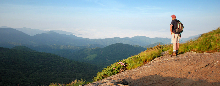
Located along the TN/NC border in Unicoi County, TN is the newly purchased U.S. Forest Service property known as Rocky Fork.  This 10,000 acre tract is very rugged, with unmarked trails and very limited trail maps.  My good friend Jimmy Humston and I decided to do some exploring along the northern-most sections of the tract with our ultimate goal being “Buzzard Rock”… a wonderful, but extremely well-earned vista at 4,600′ elevation that overlooks the majority of the property.

We began our trip in the lowlands of Higgins Creek with our first stop at the 100′ Higgins Creek Falls.  Water levels were up from recent rains giving us quite a show, but it would also leave us wading swelled streams in the cold temperatures.  Almost immediately after visiting the falls, we left the maintained trail and began a steep ascent up Birchfield Camp Branch following a primitive trail, or sometimes just following the stream itself.  Keeping our feet dry was impossible.  About halfway up there is a nice small waterfall, which is a good place to rest.  Earlier in the year I sent the coordinates to the Tennessee Landforms website for categorization, and it is now named Birchfield Camp Falls.   Eventually, we made it to Birchfield Camp Lake where we had lunch.

From the lake, we hiked up an old forest road, now named “Hidden Lake Trail” until it met up with the “High County Trail”, which basically follows the ridgeline of Rich Mountain on the Unicoi/Greene County line for approximately 5 miles.  We had nice vistas all along this ridge overlooking the Sampson Mountain Wilderness through the leafless trees.  We often had to stop and check our maps and GPS to ensure we were still on the right path as other forest roads shot off in different directions… again there are no blazes or signs to mark the way, so if you decide to hike this area read my “Trail Directions” below and carry maps (also see below) and a GPS unit as well.

Nearing mid-afternoon we still had the tough climb ahead of us up to Buzzard Rock.  With tired legs and cold, wet feet, it was a difficult final ascent, but the view was well worth it.  We decided to set up camp near that location and enjoy the vista for the rest of the evening.  My estimate is that we only hiked about 8.2 miles on Day #1, but we had a total ascent of well over 3000 feet.

I got up early the next morning to enjoy the sunrise coming up over Little Bald Mountain.  It was spectacular.  I regretted not having a better camera to document it.  After a leisurely morning, Jimmy and I were back on the trail.  We retraced our steps for the first mile or so on the High Country Trail until it connected to the Headwaters Trail, which basically follows Rocky Fork (stream) all the way to the main gate of the Rocky Fork Tract.  I think we had five or six large stream crossings on the way out… some of which took some exploring and difficult rock-hopping to maneuver, but somehow we managed to stay dry.  After passing by the Rocky Fork Trio falls we soon arrived at the car, completing a nice traverse of this beautiful property.  Day #2 was a 7.1 mile hike and almost all downhill.

On a side note:  I would like to congratulate my friend David Ramsey for recently winning the Field and Steam Conservation Hero of the Year, and he is also a finalist in the Budweiser Conservationist of the Year…. for all his hard work and dedication to the protection of the Rocky Fork Tract.  Those of us who will enjoy this wonderful treasure for years to come have David to thank for it.

_______________________________________________________________________________

———————————-

Overall
Recommendation:

Advanced backpack with good fitness and good navigational skills. Winter or early spring hike to avoid excess underbrush growth and to have good views through the trees.

Outstanding
Features:

Three Waterfalls. High elevation lake.  Vista from Buzzard Rock.

Difficulty:
Very Difficult. More than 3000 feet of elevation gain on Day #1.

Driving:
We left one car at the Higgins Creek Trailhead:  From Johnson City, take I-26 toward Erwin, and go on past Erwin to exit #43 (Temple Hill). Turn left at the stop sign at the bottom of the exit (your only option). At the next stop sign turn right onto 19W (19/23). After .75 mile, turn right onto Lower Higgins Creek Road. Follow this road for approximately 1.5 miles until it dead-ends. Park in the wide spot on the left. 

We left a second car at the end of our hike at the Rocky Fork Main Gate:  Take the Flag Pond exit off of I-26 (exit #50).  At the stop sign turn left onto Higgins Creek Road. Drive ½ mile until you reach Rt. 23.  Turn right and travel 2¼ mi. thru Flag Pond, then turn left on Rocky Fork Road. After ¾ mi. you will see a gravel pull-off to the left. Park here (out of the way of the gate) and follow the gravel lane into the Rocky Fork Tract.

Trails (please refer to the maps… mileages are also estimates:
From the parking area, you will see an old, rickety bridge in the upstream direction. Be careful crossing this bridge, but some work has been done to it since my last visit. After crossing the bridge, just stay on this trail, basically following Higgins Creek in the upstream direction. In approximately 0.9 miles you will see the 100′ Lower Higgins Falls down in the ravine to your right. It’s worth the trouble to climb down into this ravine to view the falls. After climbing back out continue on upstream for a few hundred feet, and you will come to your first ford across Higgins Creek. This will be a shin-deep ford in wet conditions. After crossing, continue for approximately 500 more feet and you will see a wide spot in the trail with an ascending valley off to your left. This is the junction of Birchfield Camp Branch and Higgins Creek. At this point, go left and leave the Higgins Creek trail, and ford the stream again (another shin-deep) to follow Birchfield Camp Branch. I stopped counting fords at this point because sometimes you are simply walking up the middle of the stream. However, just keep working your way upstream as best possible. The lower sections of Birchfield Camp Branch trail are the most rugged and it won’t give your feet a chance to dry out for walking in the stream, but just keep going upstream. Soon, you’ll end up on a decent trail that follows up the right side of Birchfield Camp Branch, however the trail gets quite steep at this point. But after approximately 2.2 miles into the hike you will pop out of the rhododendrons and arrive at the lake.  From here you will have the choice of going either right or left on the forest road, which is the Hidden Lake Trail.  Both directions will wind up in the same place, but we took the trail to the left.  After about .25 miles you will have climbed up out of the lake area to a junction where there is a small open field.  Take a right on the forest road here (you could go left here too and end up in the same place, but going right is more level).  After about 1.0 mile of level hiking (and after passing by another old road off to your right that goes back down into Higgins Creek) you will come to another junction.  This is the High Country Trail (also an old forest road).  Take a right here.  You will stay on this trail for the next ~5.0 more miles.  At one point, soon after passing the a road off the left that goes up to Wilson Knob, the High Country Trail descends sleeply down into a valley.  You will see a stream on your left as you descend here.  This is your last water source on the High Country Trail.  Continue and eventually you’ll come to another road off to your left, which is the Headwaters Trail.  Pass by the Headwaters Trail and soon you will begin your steep climb up to Buzzard Rock.  Buzzard Rock is about .75 mile from the junction of the Headwaters Trail, in one of the switchbacks.  We camped just a few feet from Buzzard Rock in the Rhododendron thicket.  On Day #2, retrace your steps back down the mountain on the High Country Trail until you get the Headwaters Trail.  Take a right on the Headwaters Trail.  It is almost all down here from here for the next 6.5 miles.  There are some more road junctions but just refer to your map to stay on the Headwaters Trail.  It’s fairly straightforward as long as you have the map.  You will have to make about 5 or 6 difficult stream crossing on day #2 so be prepared to possibly get wet.  Eventually, you will come out at the main gate of Rocky Fork.

Needed
Gear & Tips:

Trekking poles are basically a requirement to assist in the tough creek crossings. You will need them for stability in the quickly flowing stream and to help stabilize you as you move from rock to rock. Take a waterproof bag for electronic equipment and some dry clothes and socks in case you slip and get wet.

Distance:
Approximately 15.3 miles.

Time
Allotment:

2 Days

Type:
Continuous.

Vista
Rating (1-5):

4.0 – Nice views north through the trees from the High Country Trail. Tremendous 180 degree southerly views from Buzzard Rock.

Waterfall
Rating (based on a 1-50 scale):

Lower Higgins Falls: H(9) + F(5) + V(3) + W(3) + G(2+4+5) = 31

Birchfield Camp Falls: H(1) + F(3) + V(3) + W(1) + G(3+4+2) = 17

Rocky Fork Trio: H(1) + F(6) + V(1) + W(2) + G(3+3+6) = 22

Water
Crossings (one way):

Seven or eight (very difficult), numerous (moderate to easy)

Scrambling/Climbing:
Steep scramble down into the ravine to view Higgins Falls.

Hazards:
Be careful on the old, rickety bridge at the trailhead. Extreme slippery slopes and steep areas, especially at Higgins Falls. Eight difficult stream crossings, which could cause you to get wet if you fall. Take precautions to avoid hypothermia especially in cool conditions.

Maps/GPS
info:

This is the map with Trail Names that I used, however my route up from Higgins Creek/Birchfield Camp Branch is not shown on this map:  Rocky Fork map

My route up Higgins Creek can be seen on my map at the bottom of this page.

(right click on link, and chose “Save Target As” or Save As”. Download to your hard-drive and then upload to your GPS unit)

Birchfield Camp Lake and Higgins Falls Waypoints

More
Information:

3 Responses to Rocky Fork Backpacking

  1. chad

    Live in Jonesborough, and just made my first of many trips into Rocky Fork. A beautiful place to explore! Did find one interesting bit of history. From the main Rocky Fork gate I hiked the road to the first split, then turned left. Hiked into what I think was the Flint Creek area. I noticed a fairly large stream coming down from the right and decided to follow it for a bit. Not far up I started discovering some very old concrete structures across the creek similar to a sluice or lock. Well over half a dozen of these structures are spaced further upstream. Were these part of the logging operation? I would love to learn more of the history of this area!

Leave a Reply to chad Cancel reply

Your email address will not be published. Required fields are marked *

This site uses Akismet to reduce spam. Learn how your comment data is processed.