

The Dick Creek watershed sits on the northwest face of Unaka Mountain near Erwin, Tennessee. There are two ways to access this remote region. One is from the Limestone Cove area, and the other is from Rock Creek Park. I chose to hike in from the Rock Creek side.
There are four waterfalls along the Dick Creek stream, and the further you go upstream, the more difficult the terrain becomes. Lower Dick Creek Falls can be accessed completely by trail, but the three falls above it require some navigation and off-trail hiking. If you’re looking for a remote adventure to infrequently seen waterfalls, then this hike is for you!
My GPS showed a round-trip of 10 miles, but some of that was due to extra exploration (i.e. taking a couple of wrong turns), and possibly bad satellite reception. I think this hike can be done in 8 miles or so (depending on where you park in Rock Creek Park), but allow plenty of extra time for the off-trail aspect. There will be places where you’ll be finding your way through thick underbrush, climbing over or under downed trees, and ascending/descending steep banks.
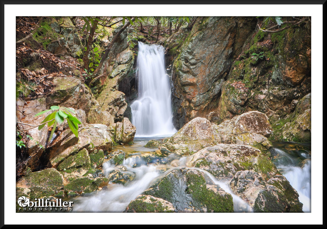
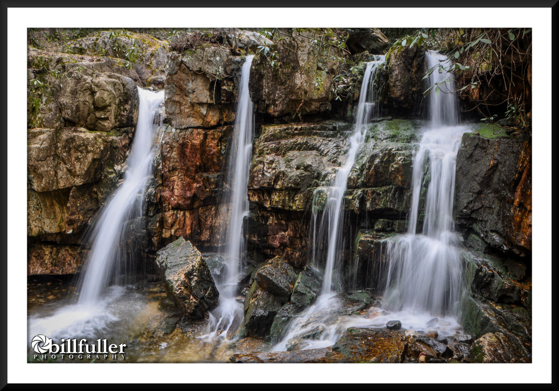
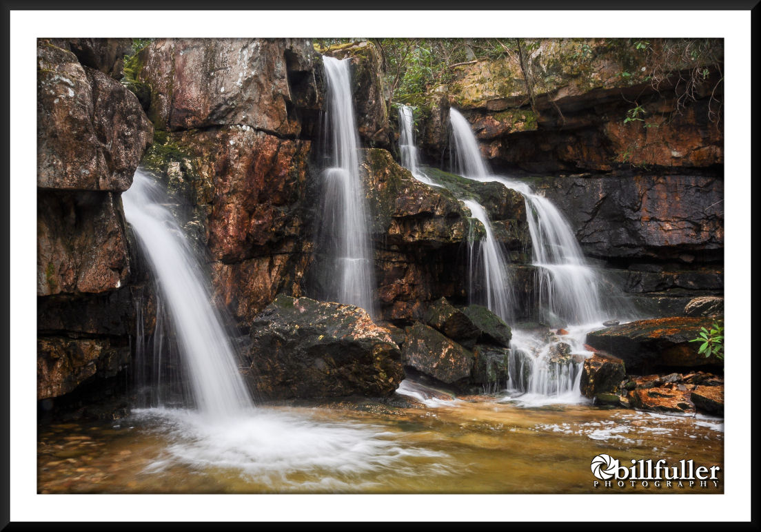
If there are official names to each of the four waterfalls, I’m unaware of what they are. I’ve only heard them referred to as Lower Dick Creek Falls, Upper Dick Creek Falls, Upper Upper, and Upper Upper Upper. All four are stunning, but I feel the most scenic is Upper Dick Creek Falls… a very unique, quadruple-drop waterfall about 25′ in height.
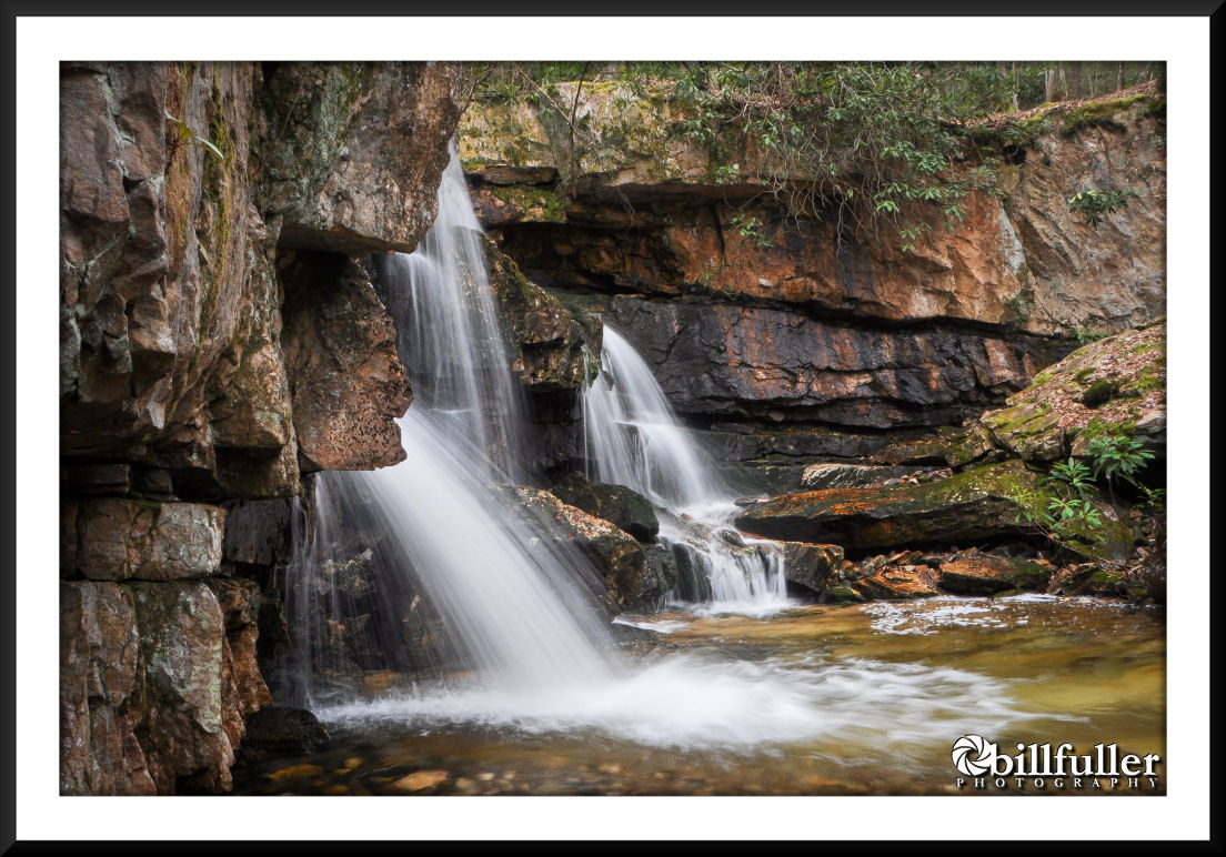
All three of the “upper” waterfalls are in close proximity to each other, but the hiking difficulty increases the further you go upstream. The final waterfall (Upper Upper Upper) requires some steep, hand-hold scrambling up a steep bank, over rock-outcroppings, and through thick underbrush.
If you decide to set out on this adventure, save yourself some trouble and print out the Trail Directions in the HIKE PLANNER. Downloading the GPS track may also assist. This is definitely a winter or spring-time hike to avoid excess underbrush growth. Prepare to get your feet wet, and maybe even a scrape or bruise. This is a difficult hike, but well worth it!
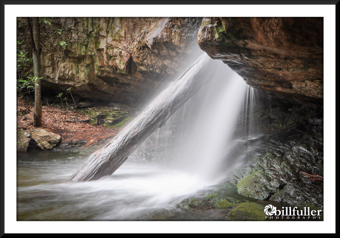
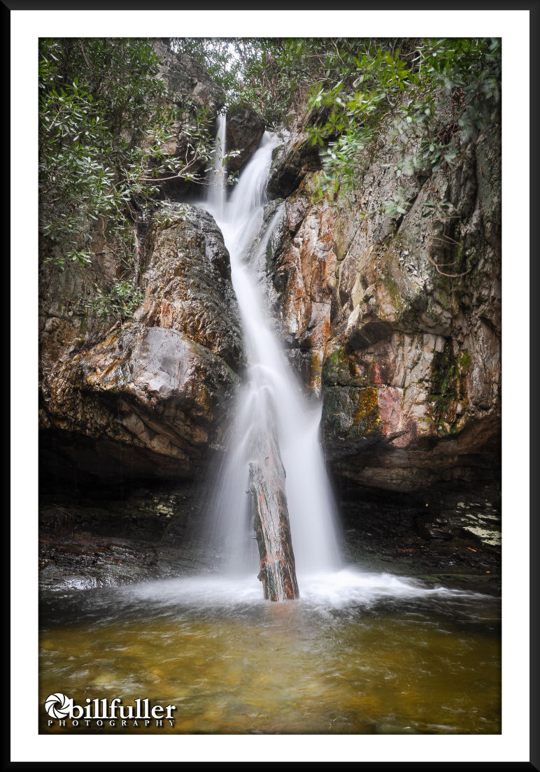
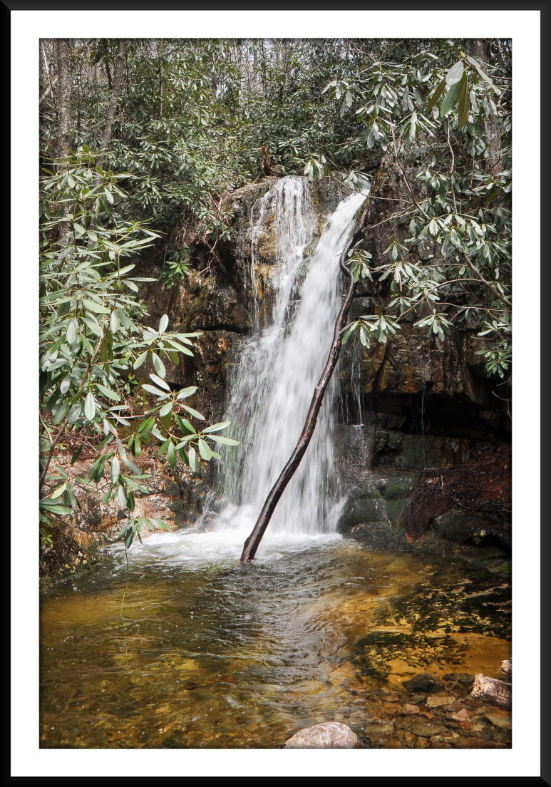
 DICK CREEK WATERFALLS Overall Recommendation: Experienced hikers with some navigational skills and good physical conditioning. Spring or winter hike to avoid excess underbrush. Wait on a good rain before going. Outstanding Features: Four remote and stunning waterfalls. Historical Rock Creek Park, constructed by the Civilian Conservation Corps. Difficulty: Difficult. Eight miles total, with approximately two miles of off-trail hiking. Elevation gain of approximately 2000′. Driving: From Interstate-26, take the Erwin Main Street Exit (#36). At the end of the ramp turn east toward town where you will immediately arrive at a stop light. Turn right onto Rt. 107 and drive 0.5 mile, turn left at stop light onto Rock Creek Road (Rt. 395). Continue on Rock Creek Road for 3.1 miles, and then turn left at the entrance to Rock Creek Park. There will be park signage there. Pay a small entry fee at the kiosk if required. Drive through the park (following directional signs) to make your way to the parking area next to the bathhouse/swimming area. In the winter months, or off-season, you may have to park further back and walk in toward the bathhouse. For purposes of hiking directions and subsequent walking mileages, the “Trail Directions” below will begin at the bathhouse. Trail Directions: Once at the bathhouse, walk NORTH toward the campground on the asphalt road. In a very short distance you’ll see a see a sign on your left directing you onto a crushed gravel trail to “Rock Creek Falls”. This a pleasant walk along Rock Creek with numerous hemlocks. Follow this trail for approximately 0.5 mile, where you’ll come to a wooden foot bridge. There is signage here. The trail to the right goes to Rock Creek Falls, but you’ll need take a left, crossing the footbridge onto the Rattlesnake Ridge Trail. In another 0.1 mile the trail splits. Take a left, following signage, to stay on the Rattlesnake Ridge Trail. Soon, you will be begin ascending a ridge while crossing a small tributary multiple times. The climb here is moderately steep in areas with some switchbacks, and as you near the top you will notice a dead Pine forest on your left that was devastated by the Pine Bark Beetle. In 0.8 miles you will arrive at Dick Creek Gap. This gap is a junction of trails and forest roads. The Rattlesnake Ridge Trail continues to your right, and there is another forest road that ascends on your left. However, you will need to take the forest road straight ahead, which begins to immediately descend from the gap. Stay on this forest road for another 0.8 miles, continually descending, where you will eventually come to a stream crossing the road. This is Dick Creek. Ford the stream, and almost immediately following the ford you will see a forest road leading off to your right. Take this road, which gradually ascends. Dick Creek will now be on your right. After another 0.4 miles you will see a trail leading off to your right (and you should also be able to hear the waterfall). Take this very short trail, going through a campsite, and visit Lower Dick Creek Falls. Backtrack to the road, take a right, and continue in the upstream direction for 0.3 miles. Along this area, you will cross a grassy field with a large campsite on your right, and soon after that you will come to another ford of Dick Creek. Cross the stream to continue on the road, which narrows on the other side. Continue walking up this road for a couple hundred feet or so, where there will be a bank on your left. When the bank diminishes to more flat terrain, you will need to leave the road, and take a left into the woods (in the direction of upstream). This is the end-point of any maintained trails. When I did this hike in the spring of 2020, there was a red ribbon hanging from a tree at this junction, but if not, just remember to leave the road (taking a left) at about a couple hundred feet after crossing the stream. Dick Creek will now be down to your left. As you work your way upstream, avoid the temptation to try to get down close to the stream as the Rhododendrons and underbrush are thicker there. Stay up higher (a couple hundred feet above the stream) as the forest is relatively clear of underbrush, but don’t get so high that you are unaware of where the stream is located. During my hike I could easily hear the stream in this area. Just keep working your way upstream for another 0.3 miles. At times you might find remnants of trail to follow, and other times you’ll just need to find the best upstream route for yourself. And even though you’ll be above the stream and not able to see it in most places, don’t worry about missing (or walking past) the waterfall. You won’t miss it, as the valley will funnel you directly to it. As you get near to it, there will be one short little climb that eventually puts you on a narrow, flat path. Once on that path, Upper Dick Creek Falls is very near and you will eventually emerge on the right side of the waterfall, somewhat above it, as it sits down in a grotto completely surrounded by rock walls. To view it from it’s base and photograph it, I had to backtrack downstream for a couple hundred feet in order to find a place to to safely climb down into the grotto. After viewing Upper Dick Creek Falls, continue upstream… again walking up the right side of the stream. The Upper Upper Falls is only a tenth of a mile or so upstream, but there is no trail whatsoever. You will have to cross a small “rock garden”, some steep terrain, and descend a very steep bank as your near the Upper Upper Falls, but it’s not that difficult. This is a beautiful location with an estimated 50′, almost vertical waterfall that has a cave-like area where you can walk underneath the plunge. The final waterfall is basically located at the very top of the Upper Upper Falls, less than a tenth of a mile upstream. To get there, you will need to cross the stream at the Upper Upper Falls, and make a VERY steep climb up the LEFT side bank. I tried going up the right side bank, but it was a failed attempt. You should be able to see somewhat of a “trail” going up the left bank. It’s very steep and can be slippery. Work your way up carefully to the rock outcroppings above you. You will need to traverse those rocks and keep climbing. Some hand-hold climbing is required through here. Once up on those rocks, there is a small, narrow passage between them that you’ll need to work your way though. It’s steep and at the time of my hike there was a rope tied to a tree at that location that helped with climbing through that passage. Once you emerge from it, you are at the top. The underbrush is thick, but from there it’s only a few short feet to the final waterfall…. Upper Upper Upper. Needed Gear & Tips: Trekking poles are recommended to assist in stream crossings. GPS unit suggested. Distance: Approximately 8 miles round-trip. Time Allotment: 5-8 hours Type: Out & Back. Vista Rating (1-5): 1.5 – Limited mountain views. Waterfall Rating (based on a 1-50 scale): Lower Dick Creek Falls: H(1) + F(5) + V(3) + W(1) + G(4+4+6) = 24 Upper Dick Creek Falls: H(3) + F(5) + V(4) + W(3) + G(4+4+9) = 32 Upper Upper Falls: H(5) + F(5) + V(5) + W(1) + G(3+4+7) = 30 Upper Upper Upper Falls: H(2) + F(5) + V(3) + W(1) + G(2+2+2) = 17 Water Crossings (one way): Numerous – small tributaries (easy). 3 – moderate (fording Dick Creek). Scrambling/Climbing: Some hand-hold scrambling over rock outcrops to view the 4th and final waterfall. Hazards: Some slippery slopes. As with all waterfalls… don’t try to climb them. Strava Link and GPS download: https://www.strava.com/activities/3323897461 |
Did this hike yesterday, 2-9-21. There are now red ribbons marking the trail all the way to the upper falls. There is a slight trail to the upper, upper falls.
Thanks for the update!